Sunnyvale presents a real mixed bag underground. In the older downtown area near Murphy Avenue, you might hit dense alluvial fan deposits in the top 30 feet, while properties closer to Moffett Field sit on softer bay mud that can be a hundred feet thick before you even smell bedrock. These contrasts aren't just academic trivia; they directly affect how seismic waves travel beneath your project site. Our seismic tomography surveys use controlled energy sources and dense geophone arrays to measure P-wave and S-wave velocities across the entire parcel. By analyzing travel times through refraction and reflection techniques, we build a velocity model that flags sudden transitions, buried channels, or weathered zones. For projects requiring deep foundation design, pairing this with a CPT test gives you correlated strength data, and when you need to confirm surface stiffness for pavement, we often link results to a CBR road study to calibrate field conditions against lab expectations.
Tomography doesn't guess at layer thickness; it measures travel times that, once inverted, give you a velocity map accurate enough to stake a footing location.
Site-specific factors
With a population of over 150,000 and sitting on the edge of the Santa Clara Valley, Sunnyvale hasn't felt a major rupture directly underneath it since the 1906 event, but the USGS shaking scenarios for a M 7.0 on the Hayward Fault tell a different story. The basin edges here can trap seismic energy, amplifying ground motion by a factor of two or more in certain frequency bands compared to rock sites just a few miles west in the foothills. Skipping a velocity-based site classification means you're defaulting to conservative assumptions that inflate foundation costs—or worse, underestimating shaking at specific periods that match your structure's natural sway. Seismic tomography cuts through that guesswork. It maps the impedance boundary at the top of the Franciscan bedrock and identifies low-velocity lenses within the alluvium that could trigger differential settlement or localized amplification during a design-basis earthquake. The City of Sunnyvale's building department reviews geophysical reports under the current IBC, and they rightfully expect velocity data, not just blow counts, when you're proposing anything taller than two stories over a basement.
Questions and answers
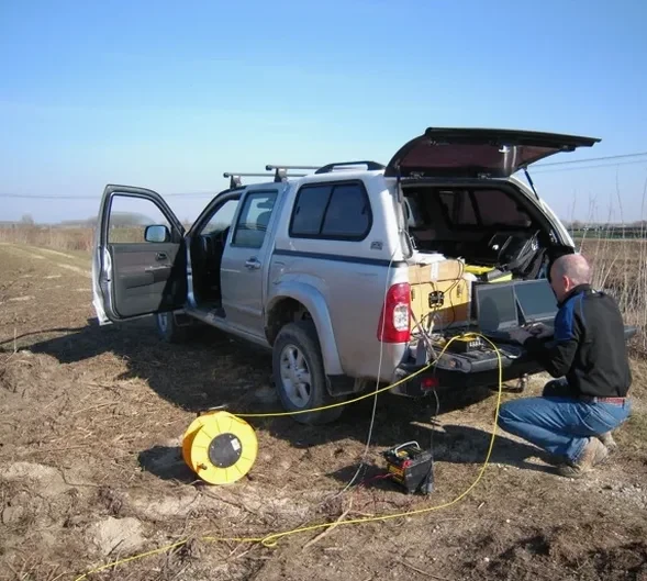
What does a seismic tomography survey cost for a typical Sunnyvale lot?
For a standard residential or small commercial parcel under half an acre, you're generally looking at a range between US$2,740 and US$5,020. The final number moves based on the number of geophone spreads we deploy, the energy source needed to punch through deep bay mud, and the processing effort for tomographic inversion versus simpler intercept-time interpretation.
How long does it take to get results from a refraction survey?
Fieldwork usually wraps up in one day for a single line, sometimes two if we're running three or four lines across a larger parcel. After that, count on four to six business days for data processing, velocity model inversion, and report drafting with interpreted cross-sections ready for your geotechnical engineer.
Can you see groundwater with seismic tomography?
Yes, indirectly. The saturated zone produces a sharp P-wave velocity jump—from around 1,600 ft/s in dry alluvium to 5,000 ft/s or more once pores are filled. That contrast shows up as a clear refractor, and we map its depth across the site. In Sunnyvale, where the water table is shallow, this boundary is often the first strong reflector we pick.
Does the city of Sunnyvale require seismic velocity data for new construction?
It's not an automatic requirement for every single-family home, but for any structure requiring a geotechnical investigation under the California Building Code—multi-story buildings, essential facilities, or projects in mapped liquefaction zones—the building department expects a site class determination. Seismic tomography and MASW are the most direct ways to provide that without drilling deep borings just for velocity.